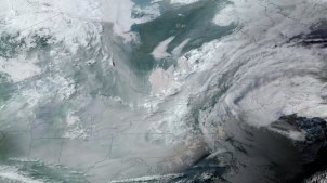
A June 2023 image from National Oceanic and Atmospheric Administration’s GOES-16 satellite shows smoke from wildfires in Canada over the midwest and northeastern regions of the U.S. GOES-16 was the first of four geostationary weather satellites in the GOES-R series. (Image via NOAA)
Interior and the Forest Service will work with NOAA to use data from a fleet of weather satellites to improve the speed and accuracy of wildfire tracking.
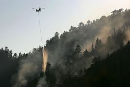
One of USDA’s new automations will help the U.S. Forest Service pay invoices faster while fighting wildfires like this one near Fawnskin, California in 2007. (Photo by David McNew/Getty Images)