Behind the technologies at the forefront of improving NOAA hurricane data
Collecting data from inside a hurricane can feel like sticking toothpicks in a donut. At least that’s how Joseph Cione, lead meteorologist for NOAA’s Hurricane Research Division, puts it.
For decades, the National Oceanic and Atmospheric Administration has used small tubular devices with parachutes attached, known as dropsondes, to gather information about the storms. Each of those devices is dropped from one of the agency’s “Hurricane Hunter” aircrafts, falling through the storm like a toothpick piercing a donut and collecting data about temperature, air pressure, humidity, and wind speed on its downward path.
Although dropsondes are a trusted method of in-situ (inside the hurricane) data collection and continue to be used, they’re limited in that they only provide snapshots of the storm as it was during a roughly five-minute descent. “The rest of the donut, we don’t know. No idea,” Cione said.
But newer technologies being tested and used during the current hurricane season — which NOAA has projected will be “highly active” — can provide more information through methods that are akin to increasing the number of toothpicks and even carving out the center of the metaphorical pastry. More information means more accurate forecasts, which can ultimately help protect lives and property, a key piece of NOAA’s mission.
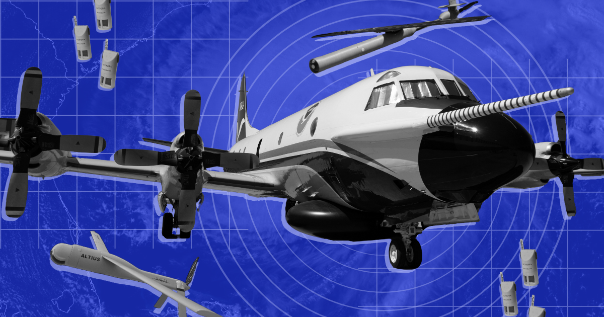
StreamSondes made by weather forecast and tech company Skyfora, for example, are a smaller parachute-less version of a dropsonde that stay in the air longer and get deployed in larger quantities, allowing NOAA to exponentially increase data collection. Additionally, two drones, the Black Swift Technologies’ SØ and Anduril’s Altius-600, can autonomously chart paths through the hurricane, collecting even more data about the inside of the storm.
Instead of “a snapshot of this critical region, now you have a movie,” Cione said.
While each of those technologies has been deployed before this year, they aren’t yet considered operational — or in other words, a routine part of the process — like dropsondes are. But that day is coming. Right now, those technologies are in data generation and validation phases. And 2024, Cione said, is the first year that NOAA has enough of the StreamSondes and unmanned systems “to really start seriously looking towards an operational transition plan.”
“If all goes well over the next two years, I would like to see us at least start to transition some of this technology to operations where it’s routine,” he said.
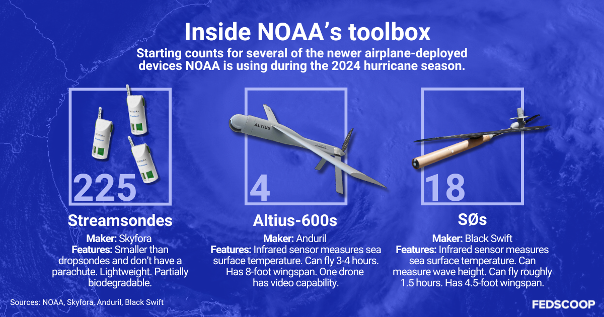
As of the beginning of the current hurricane season, the department has four Altius-600s, one of which Cione called the “media bird” that’s equipped with a camera and is able to stream video, and 18 of the smaller SØs, which have a laser that can measure things like wave height. NOAA also has 225 StreamSondes and is working on technology that allows them to put up 50 at once, he said.
Just last week, the SØ had its first flight this year in Hurricane Ernesto following work this spring to make sure it can fly farther, and the Altius is slated to be flown as early as September, Cione said.
Data from the sky
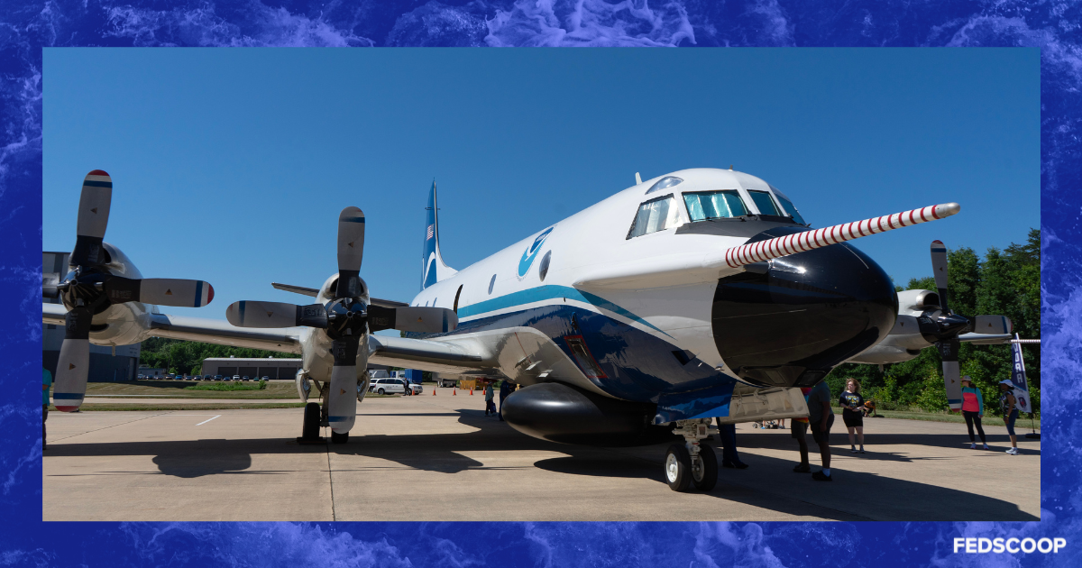
The devices are some of the latest additions to NOAA’s toolbox for hurricane tracking and monitoring, which includes satellites, floats, modeling systems, and two Lockheed Martin WP-3D Orion Hurricane Hunters, named Kermit and Miss Piggy.
Those two crewed aircrafts, commonly referred to as P-3s, generally fly at around 10,000 feet and contain their own monitoring equipment — such as radar systems that take MRI-like readings of the storm — in addition to being the method by which devices like the dropsondes, StreamSondes, and drones are deployed.
“Primarily what we’re doing is flying for science,” Andrew Utama, a P-3 navigator for the NOAA Corps., told FedScoop. Utama, who served in the Navy for 10 years before joining NOAA, is responsible for charting the plane’s route through the storm, balancing what the scientists on board want with things like fuel and airspace constraints.
The data collected by the plane is then transmitted back to NOAA’s National Hurricane Center in near real time and fed into the models for hurricane forecasting, he said.
Wallace Hogsett, a science and operations officer at NOAA’s National Hurricane Center, said over the years, better data has led to improved track and intensity forecasts, and that ultimately contributes to the level of confidence of those calculations.
“Having that confidence allows us to communicate the risk to the public and our partners, which allows those people to make informed decisions,” Hogsett said.
Uncrewed systems, such as drones, present an opportunity to get information from hard-to-reach places. “These systems are still being tested, but they have a lot of promise in terms of getting data specifically in the places that we need it most,” Hogsett said.
Surface-level importance
Specifically, the deployment of newer technologies that can go far lower than the P-3 translates into having a better idea of what the storm looks like where humans are.
“The drones are responsible for flying very low, and why low is because, first of all, when the storm makes landfall, that’s where we live,” Cione said. “We don’t live at 10,000 feet. We live right at the surface.”
Surface-level data is also important because that’s where the storms get their fuel. Through evaporation, the storm absorbs water from the sea, and monitoring the transfer of that energy is important for minimizing uncertainty in forecasts.
“We need to understand what we call these fluxes — how the energy essentially comes out of the ocean and also how momentum or energy is transferred from the storm to the surface,” he said. “So these drones, and also the StreamSondes to some degree, are giving us information that we wouldn’t get otherwise.”
Ultimately, the research division’s efforts are aimed at improving the ability to forecast the intensity change of a storm, Cione said.
“We’re pretty good at track, meaning where the storm goes, but we’re not as good at how strong the storm is going to be, including what we call rapid intensification, which is sort of a measure of how a storm changes in the 24-hour period,” Cione said.
Progression of innovation
While the new drones are state-of-the-art, using drones for hurricane data collection isn’t novel, and Cione has been a part of their implementation since the beginning.
The first flight of a drone into a hurricane was in 2005 during Hurricane Ophelia in a mission Cione conducted with NASA and the Australian-based Aerosonde Pty Ltd, which is now Textron Systems. That drone stayed up for 18-and-a-half hours, a feat that Cione still calls “remarkable.”
Since then, the technology has improved, moving from devices that take off from the ground to devices that are deployed from an aircraft and are actually designed for use in storms. In the past four or five years, Cione said development of new technologies has really “taken off.”
The SØ and the Altius-600 came from government-issued challenges to small businesses to develop technologies, Cione said (The Altius was originally made by a small business called Area-I, which was later acquired by Anduril.) Both of those drones are deployed into the storm through a tube in the bottom of the P-3 and have wings that flip out after they are dropped. They also both collect information about things like air temperature, pressure, humidity and wind speed.
Already, NOAA’s Altius-600 usage has received recognition. That drone was flown for the first time in Hurricane Ian in 2022, and earlier this year, Cione and a team from NOAA’s Aircraft Operations Center and its Acquisition and Grants Office won a Department of Commerce Gold Medal for that work. That flight was also recognized by Guinness World Records for becoming the “longest endurance inside a tropical cyclone by an uncrewed aircraft” at 102 minutes.
The data from the new technologies is currently being sent back to the Hurricane Center so it can use the information, but it isn’t yet being assimilated into numerical models that give forecasts about storm intensity and track. Assimilation into the models is the last step after researchers understand the data and its limitations, he said.
Eventually, Cione said, that data could be important for impacting the accuracy of the track forecast because it could provide more granular information about the location of the center, which might make the difference between evacuating an area or not.
On the horizon
More technologies that could help the overall hurricane tracking and predicting process are on the horizon.
Cione said in the future NOAA is looking to get drones into the stratosphere above the storm rather than just in the troposphere where they’re being deployed already. Those technologies being discussed might eventually be solar powered, have the ability to stay up for days to weeks, and be able to drop StreamSonde-like devices from above the storm, he said.
Meanwhile, at the Hurricane Center, Hogsett said they’re evaluating smaller satellites that are coming out, and some are “showing promise.” For example, satellites that use synthetic aperture radar, or SAR, technology are “providing a very, very high precision analysis of the winds underneath a hurricane at the surface,” he said.
That evaluation is in part because there are multiple SAR satellite options that are all different, he said. “We’re trying to, over time, build trust in the data, so that we can incorporate it into our operational procedures,” Hogsett said.
Weather prediction with AI modeling is also being looked at carefully. Unlike physical models, AI weather systems use algorithms and data training to predict weather and are much cheaper to run. Their downside is that it isn’t exactly clear how the model gets its results, and there likely needs to be guardrails in place to account for their limitations, he said. But that technology is also something to be excited about.
“It’s not going away,” he said. “We just need to figure out the best way to do it.”